Broken News
Costa Rica Invaded or Welcome to the Google War! (Dateline San Jose, October 27, 2010 - Past Press Deadline for the Novmber Issue {as are most things})
Oh sure, the Nicaraguans said they were just dumping river silt extracted during a dredging operation of the San Juan River. The San Juan forms a border between Nicaragua and Costa Rica in the northeast region of Ticoland. The problem is they were dumping it on a farm on the Costa Rican side of the river. Furthermore, the farm had been "occupied" by some Nica troops who, it is reported, were also helping themselves to some fresh cerdo (pigs) and other livestock after driving off the farm owners. The Nicas were definitely not being good neighbors.
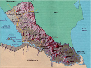
| The San Juan River is the Blue Line on the Southeastern Border of Nicaragua with Costa Rica. The Dispute Took Place in That Spit of Land at the Very Northeastern Tip of Costa Rica not Far from Tortuguerro Island. |
|
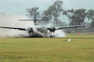
A Caribou Lands Somewhere - The Chronicles Staff was Unable to Verify That This Was the Actual Aircraft
Used
in the "Military Operation" Against Nicaragua. It Looks Like This Particular Dude is Using Skids to Land in a Rice Field |
|
The situation promised to be the biggest international incident in Costa Rica since Juan Santamaria repulsed the gringo invaders led by William Walker in 1856 and got the country's biggest airport named after himself. The naming was not there in 1856 of course; the airport was a hot-air balloon station then (oh stop it GG, your nose is growing). (go HERE for more on Señor Walker of Philadelphia)
So the Tico ire was raised, the fiery and aggressive character of the rich coast people came forth (of course, I speak here with just a little tongue in cheek). Laura (that's "Firme y Honesta" Laura, our presidenta), in a spirit reminiscent of Golda Meir, and with the government firmly behind her, wasted no time in initiating a "military operation" against the invaders. The Air Force was scrambled (a WW II surplus Caribou) and was augmented by two (unarmed) helicopters. The troops were activated and sent north (actually it was a contingent of Fuerza Publica police - remember, we Ticos have no army).
A formal letter of protest against this blatant aggression was lodged with the Nicaraguan Embassy in San Jose. The situation became tense, so tense that AM Costa Rica, the English language daily electronic newsletter, issued two special bulletins in as many days, something our reporter hasn't seem them do since our hero started taking his subscription.
Would this situation escalate and draw in the super powers? Nah, no such fun. Fortunately, within a few days, calm and reason won out (at least temporarily).
But on further digging, our crack, unstoppable Chronicles research team (guess who that is) unearthed some interesting background information on the people involved. The most significant of them was a fellow named Eden Pastora, a onetime guerilla, an original Sandinista, a belated Contra, an eventual legitimate politician and, more recently, a candidate for president of Nicaragua (2006). He lost that race (fifth place) and Danny Ortega remains the Nica president today (de facto for life or until he wants to retire, I suspect, despite what their constitution says).
Somewhere along the road to being a rebel without a definite cause, Pastora was given the nickname "Comandante Cero" or Commander Zero. Our research failed to determine exactly why they called him this, unless it was to recognize his military and political prowess. |
|
Somehow old Eden ended up in charge of dredging operations this year. Talk about a politician slinging the mud... Pastora was literally in the middle of it. Pastora's history and experience toughened him for almost anything, even dredging. When the former dictator Anastasio Somoza was finally thrown out of power in 1979, Eden was there to support the Sandinista takeover; in fact Pastora's Southern Front was the first to call themselves Sandinistas (a socialist-leftist movement named after Augusto César Sandino, a Nicaraguan general and rebel leader who was murdered in 1933). Pastora's power base was with the peasants and "indiginos" (indians or natives) of southern Nicaragua. He was very familiar with the territory he ended up dredging.
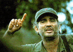
Comandante Cero (Eden Pastora) in an Earlier Life -Here Dressed in Early-Che Gueverra Chic |
|
Pastora was never a friend of Somoza because Eden's father was murdered by the Chief of Staff of Somoza's National Guard when Eden was just seven years old. But when the Sandinistas, with pastora's support, got into power after disposing of Somoza, Eden quickly became disenchanted with them when most of the new Sandinista government took up residences in the most affluent part of Managua. So he ended up becoming a Contra during the Ronald Reagan/Ollie North period of adventure, but with little effect.
So this man with the colorful political history became supreme commander of a dredge barge plying the estuaries at the mouth of the San Juan River. Reports were (and there are pictures supporting it) that his crew was trying to cut through the northeastern Costa Rican peninsula to establish a shorter route to the caribbean. If a little Tico land needed to be annexed during the process, well so be it. |
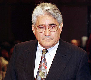
Eden as a Modern Politician - Looks a Little Like Barney Frank, Don't You Think? (I'll Bite My Tongue and
Not Take That Analogy Further). Nice Tie, Amigo |
 |
When Danny Ortega finally began to understand that he had an international incident developing, he reportedly called a halt to the project, pulled the troops off the farm and ordered his old buddy Eden to cease and desist. Pastora had to gather his barge, silt and all, put his guerilla/Sandinista/Contra tail between his legs and skeedaddle back to Managua, having become less than a hero one more time in his checkered career. At least that was what was first reported.
But it wasn't to end there. With most people thinking that a diplomatic solution, or simply a withdrawal by Nicaragua was in the offing, we went on our merry way. It wasn't long before the reality of the situation returned. Within a few days reports like the following from AM Costa Rica appeared:
"BULLETIN: (2 Nov) The Nicaraguan government appears to have moved troops onto the Isla Calero, which Costa Rica says is national territory. The foreign minister, René Castro, said Monday that the country would carry its appeal to the Organization of American States. Meanwhile air photos show a military camp on the island. This is the same place that figured in an intrusion by Nicaraguan soldiers three weeks ago.
Daniel Ortega, the Nicaraguan president, said over the weekend that the military operations along the Río San Juan were to suppress narcotics trafficking. However, José María Tijerino, the Costa Rican security minister, said that troops have set up tents and hoisted the Nicaraguan flag. There are an estimated 50 soldiers.
Costa Rican officials are sending an unspecified number of its own troops into the area. Technically the units are armed police. There was no explanation why Costa Rica did not occupy the island last week."
Update, November 9: The OAS, who Danny denounced as having no jurisdiction in the matter announced that their Secretary General José Miguel Insulza had reviewed the situation as requested by Costa Rica and suggested that the two countries should have:
"the goal of generating a favorable climate for dialogue between the two nations, to avoid the presence of the armed or security forces in the area where their presence could still be a source of tension."
Gee thanks dude, I'm sure that really gives the Nicas pause to think. I don't think this is what Jack Kennedy had in mind when he set up the OAS.
The matter was further complicated a couple of days earlier, when press reports all over the world reported that Pastora invaded because he had read a Google Earth map that showed the disputed territory was in Nicaragua. Never mind that 732 other maps, including the one below, showed the place to be a part of Costa Rica. Even trade and right of navigation agreements between the two countries, made only a few years ago show the disputed area as Costa Rican.
 |
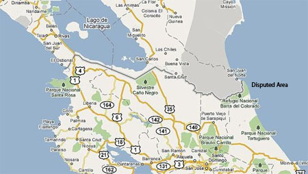 |
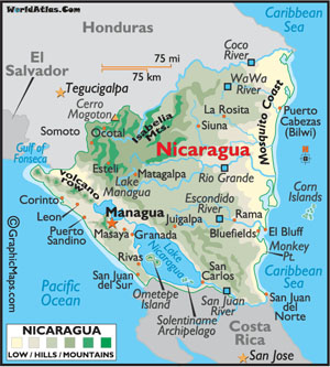
The map to the far left shows how the San Juan River is the border between the two counties for much of its eastern length. The map to the immediate left shows more detail, particularly in the disputed area to the far northeast of Costa Rica.
Note how the San Juan takes a sharp jag northward before it reaches the caribbean. If one wanted to improve and shorten that ride, one would cut a new path across the spit of land shown in green, thereby saving as much as 30 kilometers. That just happens to be where the Nicas recently dug a ditch a few meters wide recently so the river can cut the rest.
Now, you may ask, why would a country go to the trouble of creating a ditch across a remote area just to save a few klicks ride especially if it created an international incident? |
So, did they just forget where they were dredging? Was it all a Google map error? So, after some time the incident began to take on a new life. Why would the Nicas persist if all they were doing was cleaning out the river bed? One theory put forth (GG did not come up with this theory but it seems plausible; we report, you decide) is an interesting answer to this question but it first requires a short review of regional history.
Note the very large lake in the southeast corner of Nicaragua, un-cleverly but appropriately called Lake Nicaragua. Note also that the San Juan flows from the lake at its southeastern tip all the way to the Caribbean serving as a drain for the lake and surrounding mountains. Note further that the lake on its western side is very close to the Pacific Ocean, less than 25 kilometers (15 miles in Rio Linda) as the crow flies. (OK, that's enough notes for now ♫)
Back when the region was being surveyed for possible routes for a trans-isthmus canal, a second route other than the current Panama ditch was being considered. This plan visualized dredging and canalizing the San Juan from the caribbean to the lake,digging a channel across the lake and then punching through a short canal from the lake to the Pacific. It was rejected, probably as being too long (my guess is it would be 90-100 miles total versus the 51 miles of the current canal. The canal brought huge income to the country owning it (visit Panama and seeits fruits). The Nicas have never forgiven the gringos and their "pawns", the Costa Ricans (yeah, right) for this decision. Relations between the Ticos and the Nicas have been professional since then but hardly cordial.
Now, it's hard to believe the Nicaraguan action in this incident is their prelude to constructing a canal, particularly as the estimated cost in today's dollars is in the range of $400 billion. That number is virtually an impossibility for a poor country like Nicaragua. But if one could find some liberal financing, a shorter route to the caribbean along the Nica trench might save as much as $20 billion on the project cost. Every billion counts of course, unless you're the U.S. Congress.
Pero dudes Y dudettes, le voila! (some writers mix metaphors, I mix Spanglish with Franglais) There just might be one way to get the financing for such a project. One needs to remember who Danny Ortega's friends are, particularly another unfriendly-to-the-gringos dude named Hugo Chavez, that great statesman, friend of business and trying-to-be-president-for-life of Venezuela dude. Most Ticos think he's wacky which is another view they share with the Gringos. Now, Huey doesn't have the kind of moohlah needed to build this ditch as the Venezuelan economy is in shambles as a result of his nationalist/socialist policies. But he does have a friend that might have, or at the least have access to, mucho dinero - Iran.
 |
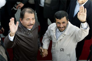 |
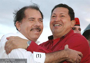
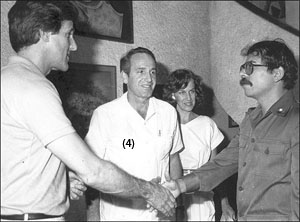
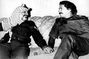
Danny and His Friends
Clockwise from the top left:
(1) Hugging and kissing Hugo Chavez.
(2) Holding hands with Iran's first and finest, Señor Ahmadinejad.
(3) Holding Hands with the late Yasser Arafat (what's with all this hand holding stuff amigo; back off, you frisky dictator devil).
(4) Greeting another dictator but not very warmly. Wait a minute, that's no dictator, that's a younger John Kerry. OK amigo Danny, go ahead and give him a big wet one on the cheek for GG.
|
 |
 |
"♥♫Kiss me once and kiss me twice and kiss me once again, it's been a long, long time...♥♫" |
These three shining examples of the world community (or is it four?) have one thing in common - they hate the U.S. And if they can make some money in their endeavors (like shipping tolls from a new canal for example) while irritating the U.S. and its "puppets", even if Costa Rica has to sacrifice a little of it's land, why that sounds too good to pass up.
What next, amigos? The saga continues.The Chronicles will stay on this story. Our Broken News will be a little late, but we'll be on it nevertheless - as long as I don't have to ride on the croc infested San Juan or interview the Nica troops on the island or have lunch with John Kerry - at the Chronicles we do not go to any lengths for a story.
We at the Chronicles editorial staff, who use the Royal "we" whenever possible note that, since the invasion began, there has been a substantial decline in the usual banter from Ticos and Gringos alike about how great it is that Costa Rica does not have an army. Pura vida.
Anatomy of a Landslide
Floods and landslides (need I add earthquakes and hurricanes?) are powerful natural forces that one should not test themselves against or flirt with. Just simply stay out of the way if possible.
For the last three months, Our Hero has been writing about the worst rainy season many a person here has ever seen, including some people who have lived here over 30 years. The collective hope a few weeks ago was that we had passed the worst of it after we had had a "normal" week. But that was not to be. The rains returned with a vengeance during the first week in November and not only caused the usual inconveniences but in some cases downright tragedy. More than 20 people were killed in a suburb of San Jose from a landslide caused by the heavy rains. Over 500 hundred people were evacuated in Parrita, a town about 20 km north of Quepos, when the Rio Parrita overflowed its banks.
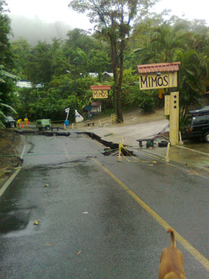
Around the same time as these occurrences, the road up to Manuel Antonio gave way just in front of the Mimos Hotel shutting the roadway down to motorized traffic. As the days of rain progressed the problem worsened as the photos below show.
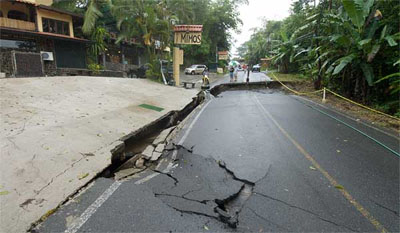 This Photo, Looking Uphill from the Quepos Side, Was Taken by AM Costa Rica on the First Day of the Incident, Note the Drop on the Upside of the Fault is Probably Less Than a Half Meter and That the Downside Perimeter of the Fault at this point is Simply a Crack. Now Compare this With the Next Three Pictures Which Were Taken on Subsequent Days. This Photo, Looking Uphill from the Quepos Side, Was Taken by AM Costa Rica on the First Day of the Incident, Note the Drop on the Upside of the Fault is Probably Less Than a Half Meter and That the Downside Perimeter of the Fault at this point is Simply a Crack. Now Compare this With the Next Three Pictures Which Were Taken on Subsequent Days.
The Serious Rains Started on Tuesday, November 2, The Following Three Pictures Roughly Represent the "Progress" of the Fault on Days 2, 3 and 4. By Friday, Two Other Cracks Appeared in the Roadway about Fifty Meters or So Down the Hill but are Not Shown Here. |
|
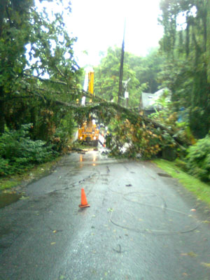
| To Add to the Problem of the Sliding Road, a Tree Fell Across the Power Lines (the Black Lines in the Center of the Photo) Near the Fault and Threatened People Walking Nearby, Like Bus Passengers Trying to Get Upwind (We Were Not Blocked form Walking Under This Problem). |
|
| By Day Three (Thursday) the Sinkhole Had Dropped Further. This Photo Was Taken in the Opposite Direction of Photo 1 and Shows How the Former Crack on the Downside Had Widened Into a Significant Gap |
|
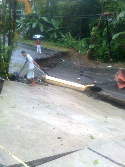
| By Friday the Upside Gap Had Widened (Dropped) to nearly a Meter, the Hotel's Cement Parking Area Had Cracked Severely and One of the Hotel Signs Had Fallen Victim to the Slide |
|
Fortunately there is a back road up the hill from Quepos that connects to the main road 100 meters or so above the slide. This was the original road from Quepos to Manuel Antonio and, unfortunately, it looks it. For most of its length the road bed is gravel and subject to rain gouging out large ravines in several places. Since this was the only exit from the hill, the municipality mounted a herculean effort to keep the back road open by repeatedly grading the most severe rough spots. Despite this, two major slides occurred along the road on different sides and in different places, both of which nearly took out the road. The road condition did not permit travel in both directions at the same time so police with walky-talkies were installed at both ends of the road to control cars going one direction at a time, conga style. It brought back memories of using the old one lane truss bridges in Parrita and Paquita.
By the end of deluge week (November 1-6) the municipalidad issued a heavy warning to people living in the Mimos neighborhood to evacuate until the true condition of the road and bordering hills was determined. Then the back road was shut for a short time on Friday night/Saturday morning and Manuel Antonians found themselves on an island. The old road was back in operation by Sunday. At that time even a casual observer could tell that It would be days if not weeks of fighting the main road problems before we would be back to normal.
So, how much rain are we talking about? One report had the rain in one 24 hour period in Quepos at 15 inches. AM Costa Rica reported that about 3 feet had fallen between Monday and Thursday night. Some forecasts called for the rain to taper off by Sunday. We hoped...and we prayed.
By Sunday, November 14 the main road was re-opened with one lane only. It was expanded to two lanes a few days later and normal bus traffic returned, albeit over a gravel surface. The road crews continued to work almost continuously through the end of the month, installing new drainage systems and reinforcing the sides of the roadbed before an asphalt surface could be laid. At this writing, it had not yet been hot topped.
One of the more interesting reports of this period was filed on Monday, 8 Nov:
"Sometime Wednesday a surge of water prompted by the heavy rains caught a man in Naranjo de Dota and swept him away. Cruz Roja (Red Cross - Ed.) rescue workers extracted the man alive Sunday from the mud and sediment downstream that had trapped him for at least 72 hours, they said."
Señor, you are one lucky dude, por la gracia de Dios!
A Rank Ranking
One of the stated goals of the Costa Rican government is to work towards being a "developed" country. I'm not exactly sure what the criteria is in this regard or what conditions will exist that will allow us to say we've reached that goal but apparently we have a way to go. An interesting piece of information passed by my e-desk the other day that is pertinent to this issue.
Now, I go to some length in this column not to be negative but I also will not paint an unrealistic and rosy picture of things when they're not true. So, what I will point out here is as objective as I can report it but, unfortunately, not flattering to Ticoland.
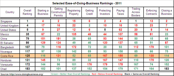
| Mexico Comes is #1 in Latin America but I'm Still Not Sure I'd Open a Taco Stand in Ciudad Juarez Given the Situation There |
|
The World Bank (you know, that supranational organization that some think is grossly under funded to support all the development projects needed in the world while others think it's the economic devil incarnate wasting big bucks) publishes an annual report on "The Ease of Doing Business" in each country.
It ranks countries on nine factors: Starting a Business, Getting Construction Permits, Registering Property, Getting Credit, Protecting Investors, Paying Taxes, Trading Across Borders, Enforcing Contracts and Closing a Business. In each category weighting is given to the number of procedures as well as the time required to accomplish the task. The categorical ratings are then combined to arrive at an overall country rating.
For the 2011 business year, Costa Rica is ranked 125 out 183 countries in the survey. Que triste. |
I suppose one could find some comfort in the fact that Costa Rica came in ahead of places like Burundi, The Central African Republic and Chad (the lowest three rankings in the report) but coming in behind Ethiopia, Bangladesh and Brunei is not encouraging. More importantly, Costa Rica ranks quite low in Latin America and comes in second to last out of six countries in Central America, with only Honduras coming in lower and the aggressor Nicaragua coming in a few points better.
Mexico is ranked number one in Latin America, with an overall ranking of 35 in the world. The highest categorical rankings for Mexico are "Getting a Construction Permit" and "Closing a Business". Evidentially no points in the ranking system are deducted for being eliminated by a drug cartel agent while standing in line for a permit.
|

